
Choosing sites
A feature of the process was that, in line with Cage’s philosophy, the sites were not a reflection of my moment by moment artistic interest but were sites at which the present and available sounds would be the subject of thought and listening. Cage traditionally removed himself from these types of decision using I Ching; I used a computer programme.
Having identified the latitude and longitude co-ordinates that delimit the north, south, east and western limits of Fair Isle then using a random number generator 60 sets of paired latitude co-ordinates (between 59.511766° and 59.552383°) and longitude co-ordinates (between -1.597932° and -1.656817°) were generated. Just using the limits to generate the locations with its underlying oblong shape meant that about 50% of the locations were outside the island’s smaller, irregular perimeter. The locations were exported to Google Earth; those that were not on Fair Isle were deleted leaving 28 island locations.
Once selected, the first 16 sites were sequentially linked to form four sets of four. Sites that were inaccessible (as judged from a map prior to visiting) were excluded and were replaced by a further site. For sites that were deemed inaccessible on attempting to visit them the plan was that they would be replaced by a further site and a subsequent visit scheduled but, as it turned out, this never happened.
The final set of 16 sites became the score for the work.
Visiting and responding to locations
Each site was visited and a recording was made. Given my interest in representing distance and movement in the landscape the sites were visited in sequence within Reel (1:1, 1:2, 1:3 etc.). Reels 1 and 2 were recorded on September 18th 2016 and Reels 3 and 4 were recorded on September 19th 2016. Thus, as each Reel progressed sequentially over time and distance, these became integrated dimensions of each Reel.
The map below shows the routes walked when recording the Reels based on their internal sequence (several of these, particularly in the middle of the island, were walked on more than one occasion).
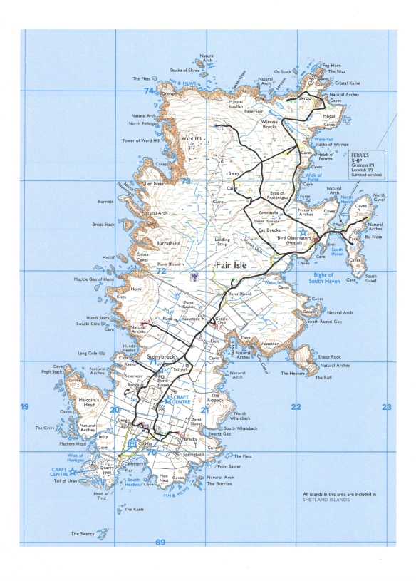
The distances of the individual Reels (1 to 4) were 2.1, 1.8, 3.8 and 5.2 miles respectively (a total of 12.9 miles).
A static sound recording was made using a SD702T recorder and a pair of DPA 4060 omni-directional microphones (with wind protection) mounted ‘binaurally’ on the sides of the crown of a wide brimmed hat. The duration of the recording was determined using random number tables but the duration was set between one and four minutes (again reflecting the structure of the reel). In addition, the walk between the sites was recorded using the same equipment.
